How to get to Anfield: Directions
Liverpool Football Club,
Anfield Road,
Liverpool
L4 0TH
tel: (0151) 263 2361
fax: (0151) 260 8813
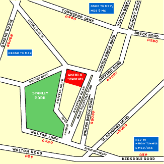
Anfield is easily accessible from all major routes into Liverpool. The ground is only 3 miles from the city centre, 4 miles from the M62 and 7 miles from the end of the M57 and M58. The ground is well signposted from the city centre.
BY CAR
From the North Leave the M6 at Junction 23 and take the A580 (East Lancashire Rd) signposted to Liverpool. Follow the A580, passing under the M57 (11 miles) then under a railway bridge (2.75 miles) finally (0.75 mile later) turn left onto the A5058 (Queens Drive) towards Widnes. Proceed for 0.5 mile turning right at the lights into Utting Avenue. Pass under the railway bridge which continues into Arkles Lane. Please note that this area is a residents parking zone and a valid permit is required to park your car in any street within this vicinity. The ground is just to the right at the far end of Arkles Lane.
From the South and East
At the Liverpool end of the M62, keep in the right hand lane and take the signs for A5058 (Queens Drive). Stay on the A5058 passing St. Matthews Church (2.5 miles) finally turning left (in 0.5 mile) at the lights into Utting Avenue (Asda should be just visible on the right as you approach the lights). Pass under the railway bridge which continues into Arkles Lane. Please note that this area is a residents parking zone and a valid permit is required to park your car in any street within this vicinity. The ground is just to the right at the far end of Arkles Lane.
From the Wirral and North Wales
From the end of the M53 or A41, pass through one of the Mersey Tunnels (Toll Fare). Whichever tunnel you use you should take the A59 (North/Preston) as you leave the tunnel. Follow this road until you see signs for the A580 (St. Helens and Manchester). As you reach the junction where the A59 meets the A580, keep in the right hand lane (A580), which turns right after the lights onto a hill (Everton Valley). Please note that this area is a residents parking zone and a valid permit is required to park your car in any street within this vicinity. As the road climbs up the hill at the start of the A580 (Everton Valley) keep in the right hand lane. After the first set of traffic lights, use the right hand filter lane to turn onto the A5089, signposted Anfield. Anfield is down this road (Walton Breck Road) on the left hand side.
BY TRAIN
Lime Street Railway Station is two miles from Anfield. A taxi from Lime St. will cost about £4.00 for up to 5 passengers. Buses go from nearby Queen Square Bus Station. On match days use the Merseyrail network to link with the Soccerbus service from Sandhills Station.
CLICK FOR PRINTER FRIENDLY VERSION